What You Need to Know About Geospatial Information Scientist or Technologist
Geospatial Information Scientist or Technologist Definition Research or develop geospatial technologies. May produce databases, perform applications programming, or coordinate projects. May specialize in areas such as agriculture, mining, health care, retail trade, urban planning, or military intelligence.
List of Geospatial Information Scientist or Technologist Job Duties
- Provide technical support for computer-based Geographic Information Systems (GIS) mapping software.
- Develop new applications for geospatial technology in areas such as farmland preservation, pollution measurement, or utilities operations management.
- Produce data layers, maps, tables, or reports, using spatial analysis procedures or Geographic Information Systems (GIS) technology, equipment, or systems.
- Lead, train, or supervise technicians or related staff in the conduct of Geographic Information Systems (GIS) analytical procedures.
- Perform integrated or computerized Geographic Information Systems (GIS) analyses to address scientific problems.
- Create, analyze, report, convert, or transfer data, using specialized applications program software.
Featured schools near , edit
What Skills Do You Need to Work as a Geospatial Information Scientist or Technologist?
When polled, Geospatial Information Scientists and Technologists say the following skills are most frequently used in their jobs:
Reading Comprehension: Understanding written sentences and paragraphs in work related documents.
Active Listening: Giving full attention to what other people are saying, taking time to understand the points being made, asking questions as appropriate, and not interrupting at inappropriate times.
Writing: Communicating effectively in writing as appropriate for the needs of the audience.
Science: Using scientific rules and methods to solve problems.
Speaking: Talking to others to convey information effectively.
Critical Thinking: Using logic and reasoning to identify the strengths and weaknesses of alternative solutions, conclusions or approaches to problems.
Other Geospatial Information Scientist or Technologist Job Titles
- Resource Analyst
- Geographic Information Systems Data Manager (GIS Data Manager)
- Geographic Information Systems Director (GIS Director)
- Geospatial Specialist
- Geospatial Technologist
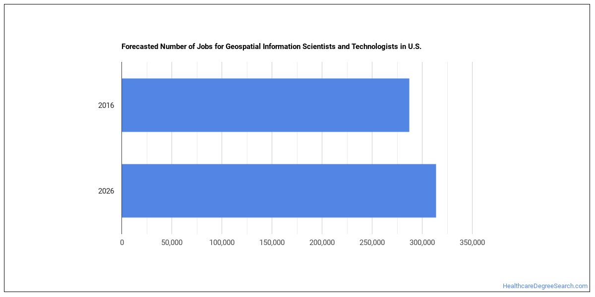
Job Outlook for Geospatial Information Scientists and Technologists
There were about 287,200 jobs for Geospatial Information Scientist or Technologist in 2016 (in the United States). New jobs are being produced at a rate of 9.3% which is above the national average. The Bureau of Labor Statistics predicts 26,600 new jobs for Geospatial Information Scientist or Technologist by 2026. Due to new job openings and attrition, there will be an average of 22,400 job openings in this field each year.
The states with the most job growth for Geospatial Information Scientist or Technologist are Washington, Utah, and Nevada. Watch out if you plan on working in Alaska, Maryland, or Mississippi. These states have the worst job growth for this type of profession.
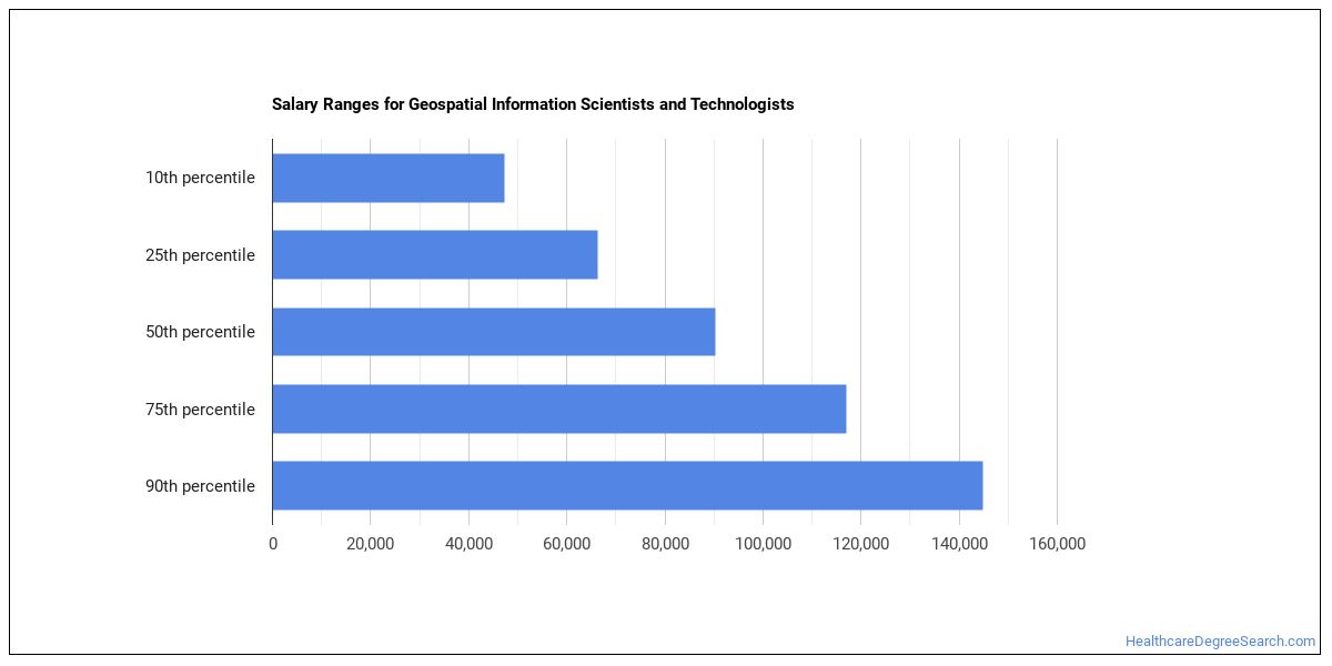
What is the Average Salary of a Geospatial Information Scientist or Technologist
The typical yearly salary for Geospatial Information Scientists and Technologists is somewhere between $47,350 and $144,820.
Geospatial Information Scientists and Technologists who work in District of Columbia, Maryland, or New Hampshire, make the highest salaries.
How much do Geospatial Information Scientists and Technologists make in different U.S. states?
| State | Annual Mean Salary |
|---|---|
| Alabama | $87,060 |
| Alaska | $98,830 |
| Arizona | $85,010 |
| Arkansas | $73,670 |
| California | $103,270 |
| Colorado | $102,470 |
| Connecticut | $100,340 |
| District of Columbia | $117,540 |
| Florida | $78,900 |
| Georgia | $90,140 |
| Hawaii | $89,960 |
| Idaho | $80,610 |
| Indiana | $79,310 |
| Iowa | $78,810 |
| Kansas | $79,300 |
| Kentucky | $79,420 |
| Louisiana | $66,600 |
| Maine | $79,790 |
| Maryland | $113,330 |
| Massachusetts | $92,110 |
| Michigan | $76,400 |
| Minnesota | $81,650 |
| Mississippi | $81,280 |
| Missouri | $82,610 |
| Montana | $68,430 |
| Nebraska | $86,230 |
| Nevada | $72,610 |
| New Hampshire | $112,440 |
| New Jersey | $99,210 |
| New Mexico | $79,540 |
| New York | $90,750 |
| North Carolina | $88,650 |
| North Dakota | $70,730 |
| Ohio | $82,440 |
| Oklahoma | $78,490 |
| Oregon | $79,610 |
| Pennsylvania | $87,040 |
| Rhode Island | $81,290 |
| South Carolina | $92,100 |
| South Dakota | $81,250 |
| Tennessee | $74,000 |
| Texas | $90,290 |
| Utah | $76,890 |
| Vermont | $72,220 |
| Virginia | $105,270 |
| Washington | $91,620 |
| West Virginia | $83,660 |
| Wisconsin | $74,600 |
| Wyoming | $75,780 |
What Tools do Geospatial Information Scientists and Technologists Use?
Although they’re not necessarily needed for all jobs, the following technologies are used by many Geospatial Information Scientists and Technologists:
- Microsoft Excel
- Microsoft Word
- Microsoft Office
- Hypertext markup language HTML
- Microsoft PowerPoint
- Web browser software
- Python
- Microsoft Access
- Data entry software
- Autodesk AutoCAD
- Microsoft SharePoint
- Adobe Systems Adobe Photoshop
- Structured query language SQL
- The MathWorks MATLAB
- SAS
- Microsoft Visual Basic
- Adobe Systems Adobe Illustrator
- Extensible markup language XML
- Microsoft SQL Server
- UNIX
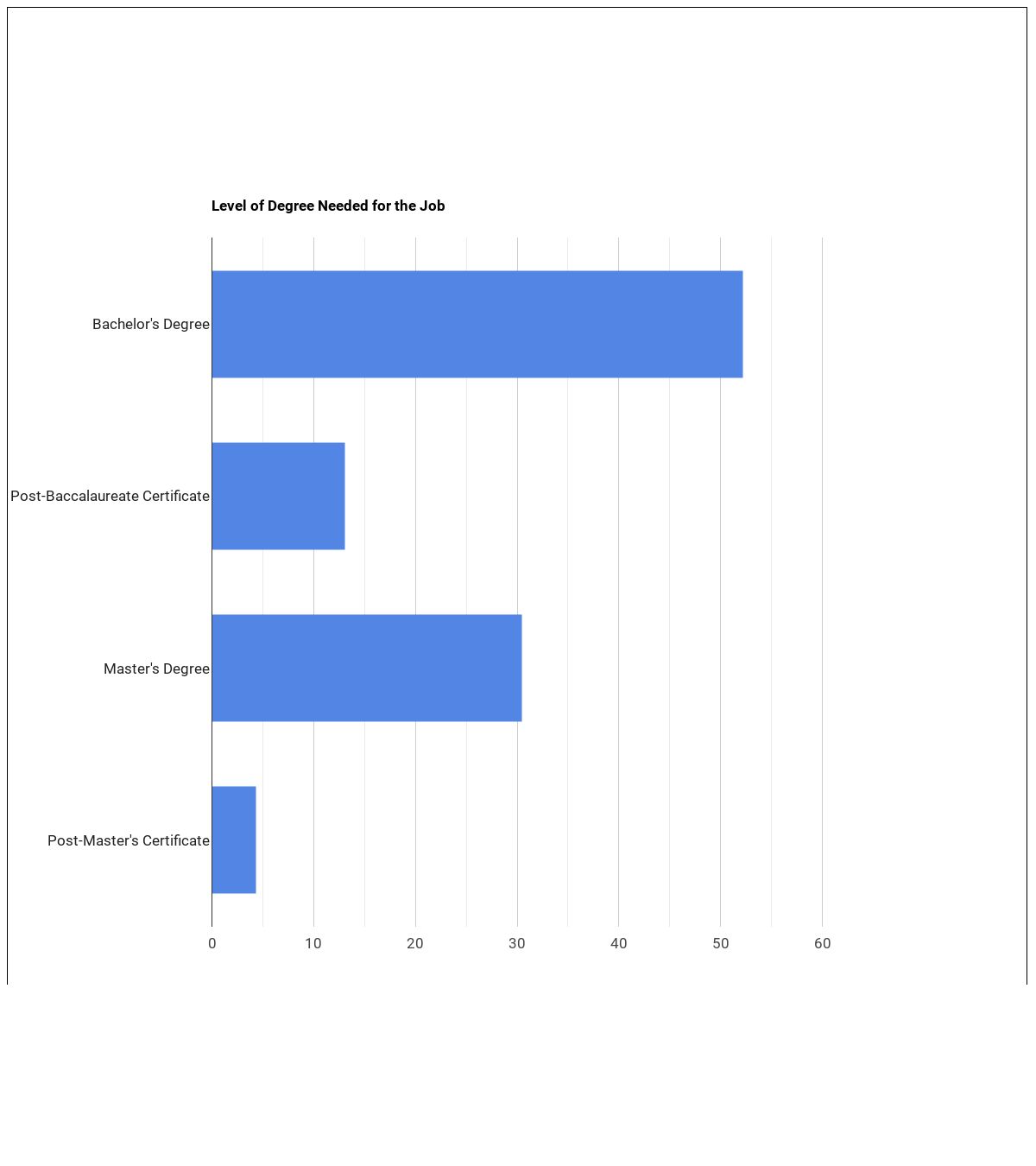
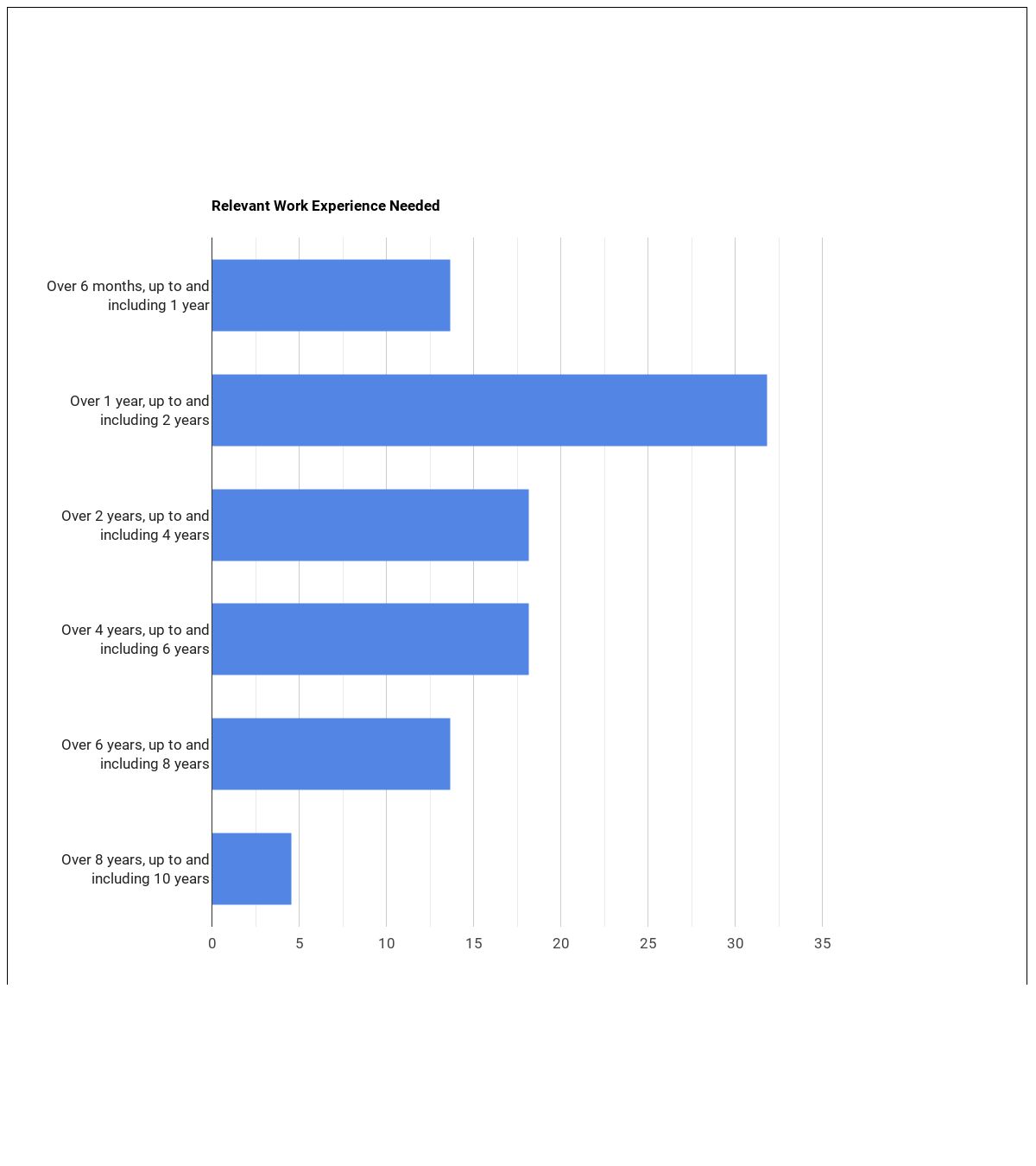
Becoming a Geospatial Information Scientist or Technologist
What education is needed to be a Geospatial Information Scientist or Technologist?
What work experience do I need to become a Geospatial Information Scientist or Technologist?
Related Careers
Those interested in being a Geospatial Information Scientist or Technologist may also be interested in:
Those who work as a Geospatial Information Scientist or Technologist sometimes switch careers to one of these choices:
References:
Image Credit: Negative Space via CC0 License
More about our data sources and methodologies.
HealthcareDegreeSearch.com provides higher-education, college and university, degree, program, career, salary, and other helpful information to students, faculty, institutions, and other internet audiences. Presented information and data are subject to change. Inclusion on this website does not imply or represent a direct relationship with the company, school, or brand. Information, though believed correct at time of publication, may not be correct, and no warranty is provided. Contact the schools to verify any information before relying on it. Financial aid may be available for those who qualify. The displayed options may include sponsored or recommended results, not necessarily based on your preferences.
© HealthcareDegreeSearch.com – All Rights Reserved.